Hike up to the valley of Champagny le Haut from the village by a beautiful trail going along 2 via ferratas and passing over the Gorges of Pontille.
Starting point: Champagny le Bas, Le Planay, carpark "Via Ferrata des Grosses Pierres", Rue de la Tante Angèle
Arrival: idem
Duration: 2:20 hrs (1h uphill)
Distance: 6.8 km
Positive drop: 408 m
Type: loop
Arrival: idem
Duration: 2:20 hrs (1h uphill)
Distance: 6.8 km
Positive drop: 408 m
Type: loop
0/ From the Planay district, at the Via Ferrata car park, go straight ahead on a wide marked path. At the crossroads, on the left, a narrower path climbs up, passes the foot of the "Grosses Pierres" via ferrata and joins the road to Champagny le Haut.
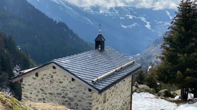
1/ Cross the road, go straight on for a few metres then take the path which climbs on the left to "Plan des Mains" (sign) and which passes near the chapel of Plan des Main.
2/ Continue on the path which passes under the via ferrata of "Plan du Bouc" and which goes downhill to "La Couaz" (EDF dam).
3/ Cross the road, the car park and the wooden bridge.
[Picnic tables and barbecues on the left after the bridge if you wish].
After the bridge, take the path on the right that rises above the Pontille gorges (sign). On the descent, at the 2nd crossroads, on the right (sign - Combe de Verdon - indicating "Champagny Le Bas - Liotraz"), the path goes down to join a track below which leads to the Pont des Chailles (alt. 1192 m).
4/ Cross the bridge on the tarmac road, take the 1st road on the right (in front of the carpenter's shop). At the 2nd right (in the bend), take a small narrow path lined with trees (short cut) which brings you to the street "rue des Perrières". Take a climbing tarmac path (with barriers) opposite; you arrive in the Rue des Eculés. Turn left, follow the road and at the crossroads turn right into the old Bozel road. Continue and at the end of the road, you will arrive at the via ferrata car park, near the rue de la Tante Angèle (starting point).
Niveau difficulté
Level green – easy
For beginners / novice
Prices
Free access.
Opening
From 01/05 to 01/11 daily.
Subject to favorable snow and weather conditions.
Subject to favorable snow and weather conditions.
Characteristic
Minimum age
5 yrs
Animals accepted
yes
Durée
2h20
Distance
6.8 km
Elevation gain
408 m
Descent
408 m
Type of itinerary
Circuit
Précision balisage
Nature of the terrain
Not suitable for strollers
Stone
Ground
♿ Tourism and Disability
Not accessible in a wheelchair
Circuit des Gorges de la Pontille
Parking Rue de la Tante Angèle Le Planay
73350 Champagny-en-Vanoise
73350 Champagny-en-Vanoise
Altitude
1250m
Champagny-en-Vanoise


